|
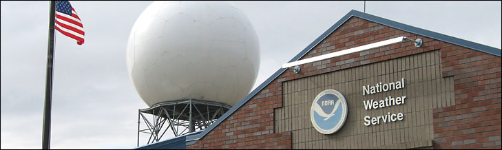 24 people work at the NOAA Weather Service Office in Spokane, which is responsible for forecasts covering 45,000 square miles. - NOAA photo. 24 people work at the NOAA Weather Service Office in Spokane, which is responsible for forecasts covering 45,000 square miles. - NOAA photo.
Science and Art
Forecasting Methow weather
by Sheela McLean
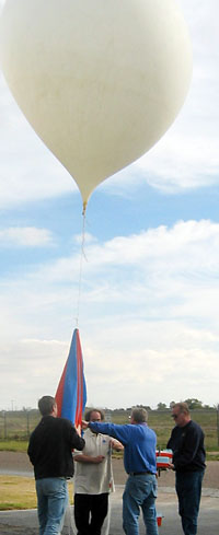 92 weather balloons like this one are launched twice daily across the country. - NOAA photo Methow weather prediction is tricky: weather radar doesn’t reach here, the terrain complicates everything, and a favorite forecasting tool - weather balloons - aren’t released from the valley.
“Quite a bit of science and a little bit of art,” goes into weather predictions and “it’s very, very difficult to forecast” for the Methow Valley, according to Anthony Cavallucci of the National Oceanic and Atmospheric Administration (NOAA) Weather Service in Spokane.
In the United States, 92 weather balloons rise daily from set stations at 4 a.m. and 4 p.m. Pacific Time. Equipment attached to the balloons sends back temperature, moisture and air pressure data as the balloons ascend about 1,000 feet per minute. A global positioning system (GPS) unit tells, within a few feet, where the balloon is at any given data point, informing meteorologists of wind speed and direction in different atmospheric layers.
The equipment on the balloon is contained in a shoebox-sized foam case with a parachute attached. When the balloon pops at about 100,000 feet, the equipment drifts back to earth. Often the equipment bundle, worth about $85, is found by a cooperative person and returned to meteorologists to be re-used, but “sometimes we never see them again,” said Cavallucci.
A NOAA supercomputer in Silver Spring, Maryland, takes data from the 92 balloons and smooshes it into various programs and models. The whole process, from releasing the balloons to the end of the supercomputer’s run, takes about four hours.
In Spokane, meteorologists pull the data and look at “what’s happening now, and what was happening four hours ago,” said Cavallucci. Then they think about what actually happened when similar information came in front of them in past years. They use their experience combined with the model from the NOAA supercomputer and a little bit of artistry to generate the forecast that most customers use daily.
From Seattle, weather radar is blocked by the North Cascades. From Spokane, it is hampered by both distance and terrain. Cavallucci said that improving radar is a high priority but budgets just aren't stretching that far. Radar stations also stand in Pendleton and Portland, Oregon.
Ground stations near Methow, Loup Loup, Salmon Meadows, Winthrop and at the North Cascades Smokejumper Base also send data to Spokane. So does equipment at two old fire lookouts, Leecher Mountain and Monument 83 (on the Canadian border). There are also stations near Mazama and at Hart’s Pass, Swamp Creek and Rainy Pass that add to the data mix, giving the Spokane forecasters a way to refine their Methow Valley predictions.
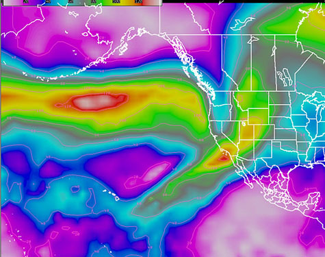 This "jet image" shows wind speeds at about 20,000 feet. The white, red, orange and yellows indicate very strong winds - in excess of 100 knots - moving toward Washington. This map is a snapshot, not a prediction. Current conditions from the many weather stations is available online (see links below). One user, Kurt Oakley, of Morning Glory Balloons, says wind prediction is about half of what hot-air balloon pilots work on, and “it’s the weather that’s the most fun.”
The Spokane forecasters could get a better handle on local weather if more locals here joined a Weather Service public program named ‘Cocorahs’ - community collaborative rain, hail, snow. Cocorahs enlists locals to gather precipitation data. If people sign up to measure Methow precipitation and get the results to the Weather Service, forecasters can refine their knowledge of Methow Valley weather. In the future, when they see a familiar weather pattern forming, they will be better able to guess how much precipitation might fall.
“It’s really valuable,” said Cavallucci. Anyone interested can check out www.cocorahs.org
Cavallucci hails from Texas, where the terrain is fairly flat, and weather prediction is easier. “I’m humbled every time I work the forecast desk,” by the expertise of the NOAA forecasters in Spokane who have been there longer, he said.
The Spokane office has a total of 18 meteorologists (three are mostly managers). The office also holds a service hydrologist, an information technologist, an electronic systems analyst, two electronic technicians, a regional facilities worker, and an administrative assistant. Most of the 122 offices across the country are staffed similarly according to Cavallucci.
The Spokane office’s forecast area is roughly 45,000 square miles. On the west, its bounded by the Cascade Crest from the Canandian border to Chelan County. On the east, it covers the Idaho Panhandle from the border south to Lewis and Nez Perce Counties.
Weather stations in our area: www.wrh.noaa.gov/mesowest/mwmap.php?wfo=otx&map=otxw&list=1&sort=name
Weather stations in other or larger areas: www.wrh.noaa.gov/mesowest/
3/15/2012
|