home | internet service | web design | business directory | bulletin board | advertise | events calendar | contact | weather | cams

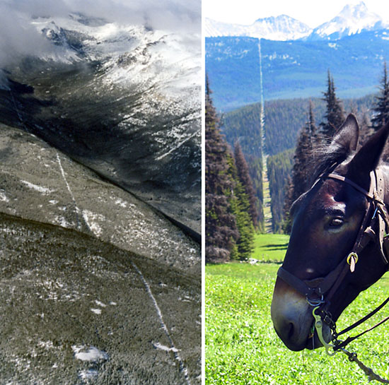 Winter and summer views of the long, straight swath through the wilderness that marks the Canada - United States border. Photos by Kit Cramer Winter and summer views of the long, straight swath through the wilderness that marks the Canada - United States border. Photos by Kit Cramer
Tending the Line North of the Methow Valley are mountains. Across those mountains, east and west, runs a straight - extremely straight - swath cut through the forest. The swath and the official small, metal monuments located along it divide two countries: Canada and the United States. “Over mountains, down cliffs, along waterways and through prairie grasses, the line snakes . . . 5,525 miles across North America, tranquil, undefended but not uncared for,” according to the International Boundary Commission website. (5,525 miles includes the boundary between Alaska and Canada). The border that marks the northern edge of the Pasayten Wilderness was last cleared in 2002, according to Kyle Hipsley, Acting Commissioner of the United States section of the International Boundary Commission. Officially, the Commission's work is described as maintaining the boundary in an effective state of demarcation. This is done by inspecting it regularly; repairing, relocating or rebuilding damaged monuments or buoys; keeping the vista cleared, and erecting new boundary markers at such locations as new road crossings. 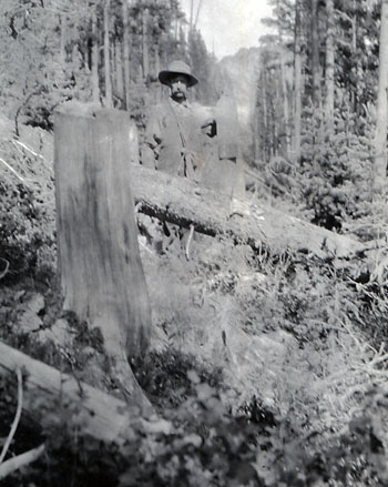 This old photograph appears to show a man standing next to a monument along the border - not nearly as tidy as the border appears today. Photo courtesy Shafer Museum This old photograph appears to show a man standing next to a monument along the border - not nearly as tidy as the border appears today. Photo courtesy Shafer Museum“It’s still all hand work,” Hipsley explained, in the mountainous areas of Cascades and Rockies. The work is contracted out about 80 miles per contract and completed with mules and chainsaws in such areas, Hipsley explained. And in the rougher portions, aided by helicopters. Border wdith varies, but the 20 feet recommended in 1925 is the standard. In appears wider where it forms one boundary of the Pasayten Wilderness. The border didn’t appear suddenly and completely in this area. On paper, the Oregon Treaty of 1846 extended the boundary from the summit of the Rockies westward along the 49th parallel to the Strait of Georgia and south and west through Juan de Fuca Strait to the Pacific, according to the website. By 1874 the boundary from the Atlantic to the Pacific Ocean had mostly been surveyed, and much of it laid bare. But by1908 the boundary had become overgrown and the monuments were obliterated. The International Boundary Commission was created then to re-establish and map that boundary. In 1925, the Commission took on the job of the boundaries permanent caretaker. The Commission also regulates, under provisions of the 1960 International Boundary Commission Act, all construction within 3 metres or 10 feet of the boundary and is responsible for defining the boundary location in any legal situation involving the border. 10/8/2012 Comments
|