home | internet service | web design | business directory | bulletin board | advertise | events calendar | contact | weather | cams

|
The Other Side of Town Building a pedestrian trail through Winthrop along the Methow and Chewuch rivers has been an on-and-off local dream for decades. But in the last few months the idea has been generating more than talk. 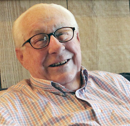 RiverWalk proponent Larry Therriault, who personally hired a surveyor and engineer to jump-start the latest effort. Photo by Karen West RiverWalk proponent Larry Therriault, who personally hired a surveyor and engineer to jump-start the latest effort. Photo by Karen WestThanks to the financial largesse of valley native Larry Therriault, a route survey and preliminary engineering work has been completed and donated to the town of Winthrop, which has applied for state money to start trail design and construction. Proponents should know shortly whether the legislature will pass a budget that covers that request. Meanwhile a small group of volunteers is talking with property owners and identifying what it would take to build a riverside walkway to eventually stretch from the Spring Creek Bridge on the south end of town to the existing Sa Teekh Wa suspension footbridge across the Chewuch River on the north end. The “primary option” under discussion, according to Town Planner Rocklynn Culp, is having the first phase of the trail built south from the town parking lot behind the Tenderfoot, passing under the Highway 20 bridge over the Chewuch River and extending to the south property line of Trail’s End Book Store. “That stretch seems relatively feasible and an opportunity [to] make the trail very visible in a way that could help propel the remainder of the project,” Culp told Grist, cautioning that a great deal of information must be gathered before a specific plan takes shape. 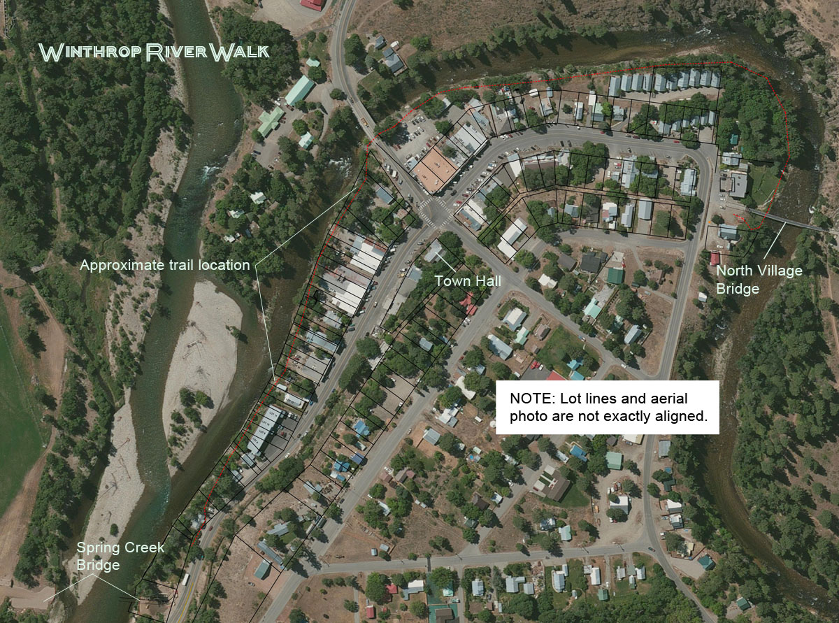 The survey work funded by Larry Therriault included a preliminary location for the trail, shown here on an aerial photo of Winthrop. CLICK TO ENLARGE The survey work funded by Larry Therriault included a preliminary location for the trail, shown here on an aerial photo of Winthrop. CLICK TO ENLARGEFour to six feet wide and handicapped accessible, the trail would be paved or graveled. In some sections, elevated wooden walkways would be built. Therriault, a retired lawyer and businessman who recently celebrated his 90th birthday, lives in Seattle with his wife LaVaughn and also lives part-time at their home in Winthrop. The extended Therriault family is well known among longtime valley residents. Sophie Therriault, Larry’s grandmother, owned and operated the Winthrop Hotel [now Carlos’ 1800 Mexican Grill and Cantina] in the 1930s. Therriault said one day he asked himself, “What would be the best thing that could happen to Winthrop?” His answer? “A fabulous walk” along the river. It would draw more visitors, be good for local business and enhance property values on both sides of Riverside Avenue, he reasoned. He also thought about what the town would need to move the idea beyond “just talk.” So last year he hired, at his own expense, surveyor Bill Tackman to put together a map and legal descriptions of all the lots along the river, and Larry Zimmerlund to do some engineering work. He gave their reports to Culp. More recently, Therriault said he has offered to pay up to $30,000 to build a pedestrian walkway under the existing Highway 20 bridge over the Chewuch River on Bridge Street. He told Grist that the donation would be made with the caveat that the town would honor his late father by having “a little plaque there saying ‘Paul Therriault Underpass’.” 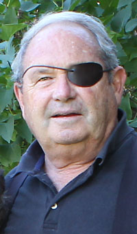 John Hayes has promoted the RiverWalk idea for years. Photo by Solveig Torvik John Hayes has promoted the RiverWalk idea for years. Photo by Solveig TorvikJohn Hayes, who has advocated building a RiverWalk for many years, and Curtis Edwards, a semi-retired Winthrop resident and walk proponent, are talking with property owners and looking at options for getting pedestrians across Bridge Street, preferably with an underpass. Hayes, a specialist in property title searches and active in open space conservation, was a founder of the Methow Institute Foundation, which holds eight right-of-way deeds donated for the RiverWalk. But he told Grist that under state law, those deeds cannot be transferred to the town sooner than six months before the project is formally launched. Hayes also was a leader of the decades-long effort to obtain easements for the Community Trail, a key link in the Methow Valley Sports Trail Association’s system. Tackman has said he will donate all additional survey services through the completion of the project. Edwards said he volunteered to help Hayes with the RiverWalk in whatever way he can be useful. “The focus right now has been under the [Highway 20] bridge,” he said. Culp and others, including Edwards, recently made on-site walks of the proposed route with representatives from the state departments of transportation, ecology and fish and wildlife to identify specifics that would need to be addressed during the design phase, Edwards said.
The Financial Challenge The first of several challenges to building a Winthrop RiverWalk is funding, which the town is seeking from the state’s Recreation and Conservation Office, the entity that provided matching funds for the Susie Stephens Trail and Spring Creek Bridge. The RCO has agreed that a portion of the money the town hopes to receive to extend the Susie Stephens Trail southward from its present terminus at the end of Norfolk Avenue to a Highway 20 crossing by the Virginian Motel can be used for design and construction of a pedestrian trail behind downtown businesses along the river, according to Culp. 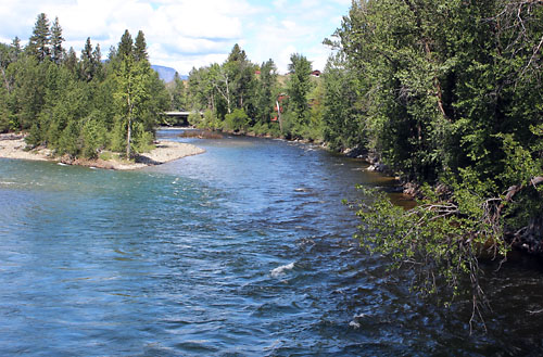 Phase one of the proposed RiverWalk would start at the bridge over the Chewuch River at the top of this photo and run south along the river bank on the right. When the southernmost portion is eventually completed, it would connect with the Spring Creek Bridge, from where this photo is taken. Photo by Solveig Torvik Phase one of the proposed RiverWalk would start at the bridge over the Chewuch River at the top of this photo and run south along the river bank on the right. When the southernmost portion is eventually completed, it would connect with the Spring Creek Bridge, from where this photo is taken. Photo by Solveig TorvikShe said her “wild guess” is that perhaps $100,000 might be left over from Susie Stephens Trail Phase II to get started on the RiverWalk project. “My bias would be towards balancing our expenditures in a way that allows us to construct some trail. I suspect the design is going to be expensive and we will need to decide how far to go with that so as to preserve money for construction,” she told Grist. But the legislature, meeting in special session, has not yet approved funds for the RCO’s budget requests. Winthrop has two pending. The first is for $365,000 for Phase II of the Susie Stephens trail and the first phase of the RiverWalk. That project ranks fourth on the RCO’s list for funding. Winthrop also is seeking $497,000 from the RCO to refrigerate the ice rink, a project estimated to cost $995,000. The ice rink grant ranks twelfth on the RCO list. If the legislature approves the RCO’s $40 million request, both Winthrop projects will be funded, said Culp. With state funding in hand to pay half the RiverWalk cost, Culp said the remainder would come from the town, private donations and donated labor. She stressed that the impetus for the RiverWalk must come from the town’s business community, not town officials. “Both projects will require major commitment from the community, and we should only undertake them knowing that we have very strong support from citizens,” she told Grist. Winthrop resident Ardis Bynum, who presented the town’s request for trail funds to the RCO, said, “I will probably be helping raise money at some point…I will be involved.” But she said RCO funding needs to happen first so there is something to match and “generate excitement.” The Property Owners 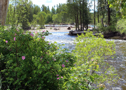 A view just above the confluence of the Chewuch and Methow rivers along the route of the proposed Riverwalk. Photo by Solveig Torvik A view just above the confluence of the Chewuch and Methow rivers along the route of the proposed Riverwalk. Photo by Solveig TorvikAnother RiverWalk challenge is getting all affected property owners on board. Three or four owners between the Bridge Street crossing at the northwest end of town and the Spring Creek Bridge at the south end of town have indicated that they do not support the project or have not committed to it, according to Hayes. The northwestern-most property owner in the phase one route under discussion is Haub Brothers’ Enterprise Trust, which owns the building at 87 Bridge St. that adjoins the bridge and houses North Cascade Land and Home Company, and the Sheri’s Sweet Shoppe building at 207 Riverside Ave. Hayes characterized the Haubs, owners of Sun Mountain Lodge, as supportive of the trail. The RiverWalk would continue south behind the Farmer’s Exchange Building, formerly owned by Mazama resident Ken Westman, who donated a trail easement through that property. The proposed first phase of the trail would terminate at the southern boundary of Trail’s End Book Store. That building is owned by Brian and Amy Sweet, who live out of state and whose support for the project has not been ascertained, according to Hayes. Westman, Hayes and Therriault appeared in videos promoting the RiverWalk produced last winter by the Winthrop Chamber of Commerce. “People are going to go to the river and if they can do so safely, that’s the way to go,” Westman said in the video. Engineering Issues Finding a way to get pedestrians across Highway 20 at Bridge Street ranks as a key challenge. “Step one seems to be solving the dilemma of crossing Bridge Street, with the preferred option being an underpass if it is feasible,” said Culp. The Zimmerlund engineering study paid for by Therriault concluded that crossing under the bridge is feasible, according to Hayes. However, the state DOT’s local program engineer, Paul Mahre, has informed Culp that the department has significant concerns with that option. The bridge was built in 1961 to different standards than apply today, he said. 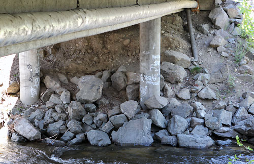 Washington State Department of Transportation engineers say they are worried about the proposal to build the RiverWalk trail under the Highway 20 bridge over the Chewuch River. Photo by Solveig Torvik Washington State Department of Transportation engineers say they are worried about the proposal to build the RiverWalk trail under the Highway 20 bridge over the Chewuch River. Photo by Solveig Torvik“The roadway slopes under the structure were built on a 1:1 ratio which would not be acceptable today. The steep slopes make it difficult to construct a retaining wall that will meet your minimum clearance without reducing the hydraulic opening,” Mahre wrote. If that opening is reduced, Mahre continued, “it increases the possibility of roadway failure. The bridge is cantilevered beyond the piers and not supported by wing walls, so they essentially just rest on the fill of the roadway. This means that failure of the rip-rap to protect the slope would result in the roadway failing rather than the bridge.” Mahre added that “It appears in order to maintain an eight-foot vertical clearance the elevation of the trail is below the maximum high water mark which may result in the trail being under water in extreme occurrences.” “If the river got to that stage, all of the bottom of town would be flooded,” retorted Hayes, who disputed the DOT’s conclusions about the feasibility of crossing under the bridge. Mahre also said a pedestrian underpass would be “very expensive and time consuming and would be a difficult permitting process” involving the WDFW and the U.S. Army Corps of Engineers. The Zimmerlund study estimated the cost at about $30,000, according to Therriault. 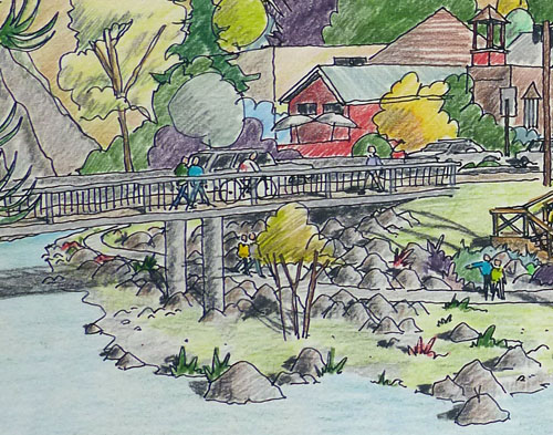 Part of a conceptual drawing of the RiverWalk trail done by Curtis McGuire in 1995 shows it passing underneath the Highway 20 bridge. Courtesy Rocklynn Culp Part of a conceptual drawing of the RiverWalk trail done by Curtis McGuire in 1995 shows it passing underneath the Highway 20 bridge. Courtesy Rocklynn CulpInstead of a bridge underpass, Mahre suggested that the town consider “constructing a 10-foot culvert under the roadway to the east of the structure,” which would require “an open cut of the highway.” He estimated that option would cost between $50,000 and $75,000 but be less expensive than going under the bridge. The least expensive option, according to Mahre, would be to place a crosswalk and pedestrian signal at the east end of the bridge, which he acknowledged “is probably the least desirable from a pedestrian standpoint.” He estimated the cost of that option at “plus or minus” $25,000. Crossing under the bridge would be “super duper expensive,” Culp told Grist. “We’re trying to understand how much this is going to cost and if it’s even feasible.” In 1996 Hayes commissioned a soil, design and engineering study by G. Wooten and L. E. Smith. Their survey identified other challenges to building a riverside walk. “Construction of a trail could be difficult along some sections,” the report said. Narrow riparian corridors, unstable and eroding banks, steep grades, too little or too much vegetation, and the annual high water mark were cited as issues to be dealt with in constructing the trail. Rip-rap will be needed to tame the rush of water that pounds the east riverbank where the Methow and Chewuch rivers converge, the survey said. The shifting position of the sandbars at the rivers’ confluence makes the flow there “turbulent and unpredictable,” the report noted. But adding rip-rap to shore up unstable, eroding banks means “the channel may then be restricted from spreading out during floods.” The survey concludes: “Notable on this survey are the unstable banks, particularly from the north [Chewuch River] bridge to the south end of town, where the river may pose a threat toward structures.” Hayes said RiverWalk proponents are exploring funding options for bank stabilization work. A Project Long Discussed Culp told Grist that a RiverWalk has been talked about for “at least the past 15 to 20 years …When I came [in 2002] it was already a talked about concept.” She added that “nothing formal had been done by the town” as far as she knows. She cited the 1996 survey commissioned by Hayes, which included a set of conceptual drawings, and the river overlook behind the Farmer’s Exchange Building. “Before I came to the town, Ken Westman worked with Chris Johnson and they worked on a path to the river behind the [then Westman-owned] Farmers’ Exchange Building,” Culp added. “I think they hoped that would build momentum.” It didn’t. 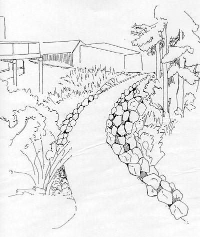 A 1996 artist's conception of a section of the proposed RiverWalk trail. Image courtesy John Hayes A 1996 artist's conception of a section of the proposed RiverWalk trail. Image courtesy John HayesIn 2004, Culp said Winthrop and Twisp were approached by Bob Thorpe, of R.W. Thorpe and Associates, Inc., a planning consultant who lived in Seattle and owned property in the Methow Valley. His vision was for a multi-use pedestrian, biking, equestrian trail that connected the towns. Thorpe volunteered to have his firm, which specialized in land planning, economics and landscape architecture, draw up the preliminary concept. That 42-page document is dated December 2004. Again, nothing happened. “My sense is that the last two or three years the talk has ratcheted up,” Culp said, adding that there is an “increasing rumble” now that the Spring Creek Bridge is complete. “I think it’s exciting.” She allowed there are lots of issues “to tease through,” but said the pending RCO grant would be used to start the permitting and design process. “We count on a lot of volunteer time and contributions to make it happen,” Culp said. “My hope and vision for how this project will unfold is that it will really be a strong partnership between the chamber and the town with the chamber leading the charge,” Culp said, acknowledging that it needs the support of business owners. Julie Muyllaert, a member of the town planning commission and president of the Winthrop Chamber of Commerce, said “nothing formal has happened yet” although the chamber board has discussed the RiverWalk. “The chamber will take a role in working with businesses and putting our support behind the project,” she said. Muyllaert also agrees with Culp that completion of the Spring Creek Bridge has sparked support for the RiverWalk because now people “can see the possibilities.” Joe Brown, Muyllaert’s partner and co-owner of Methow Cycle and Sport, also supports the RiverWalk. “It should have happened a long time ago,” Brown said last winter as he was completing a term as chamber president. “We live in this recreational nirvana, if you will, but you can’t walk safely from one end of town to the other.” Despite the hurdles, Hayes said he remains optimistic that Winthrop will prevail in building its long-sought RiverWalk. His message is: ”Quit looking at government to do everything.” ”The whole Barn was built for the town of Winthrop with donations. The whole Community Club in Mazama came from donations. That’s what I want to bring back. We weren’t waiting for Big Brother.” 6/10/2013 Comments
|